The property assessment industry is experiencing a technological revolution. Gone are the days when surveyors relied solely on tape measures, manual sketches, and weeks of painstaking fieldwork. Today, 3D Laser Scanning and Mobile Mapping: Capturing Reality for Precise Property Assessments represents the cutting edge of reality capture technology, transforming how professionals document, analyze, and value properties across urban landscapes. This shift from traditional methods to advanced scanning systems is not just about speed—it's about achieving unprecedented accuracy while dramatically reducing project timelines and costs.
As property markets become increasingly complex and stakeholders demand more detailed documentation, the integration of laser scanning and mobile mapping technologies has moved from specialized applications to mainstream practice. Whether assessing a historic building in central London or documenting a modern commercial tower, these technologies deliver centimeter-level precision that eliminates guesswork and provides stakeholders with digital twins that precisely match existing conditions.[2]
Key Takeaways
✅ Static Terrestrial Laser Scanning (TLS) achieves survey-grade precision of 1.9mm, making it essential for mechanical rooms, floor flatness measurements, and applications requiring extreme accuracy[1]
✅ Mobile LiDAR systems operate 10 times faster than static scanners, capturing 100,000–150,000 square feet per day compared to static's 10,000–15,000 square feet per day[1]
✅ Hybrid workflows combining both technologies represent industry best practice, using static scanners for survey control and critical areas while mobile systems rapidly capture the remaining spaces[1]
✅ Mobile capture reduces field costs by 50–70% compared to static scanning, though post-processing requirements increase by 15–20% due to data interpretation needs[1]
✅ Reality capture has become mainstream in 2026, with hardware costs dropping significantly while performance improvements deliver 2 million points per second from modern scanning systems[3]
Understanding 3D Laser Scanning Technology for Property Assessments
What Is 3D Laser Scanning?
3D laser scanning is a non-contact, non-destructive technology that uses laser beams to rapidly capture the precise three-dimensional shape of physical objects and environments. The scanner emits millions of laser pulses per second, measuring the time it takes for each pulse to reflect back from surfaces. This process creates a dense collection of data points—called a point cloud—that represents the exact geometry of the scanned space with millimeter-level accuracy.
For property assessments, this technology offers transformative advantages over traditional surveying methods. Instead of manually measuring individual features and creating simplified floor plans, surveyors can now capture entire buildings—inside and out—in a matter of hours, creating comprehensive digital records that preserve every architectural detail, structural element, and spatial relationship.[3]
Static Terrestrial Laser Scanning (TLS): The Precision Standard
Static terrestrial laser scanners represent the gold standard for applications requiring extreme accuracy. These tripod-mounted devices remain stationary during operation, systematically rotating to capture a complete 360-degree view of their surroundings from a fixed position.
Key characteristics of Static TLS include:
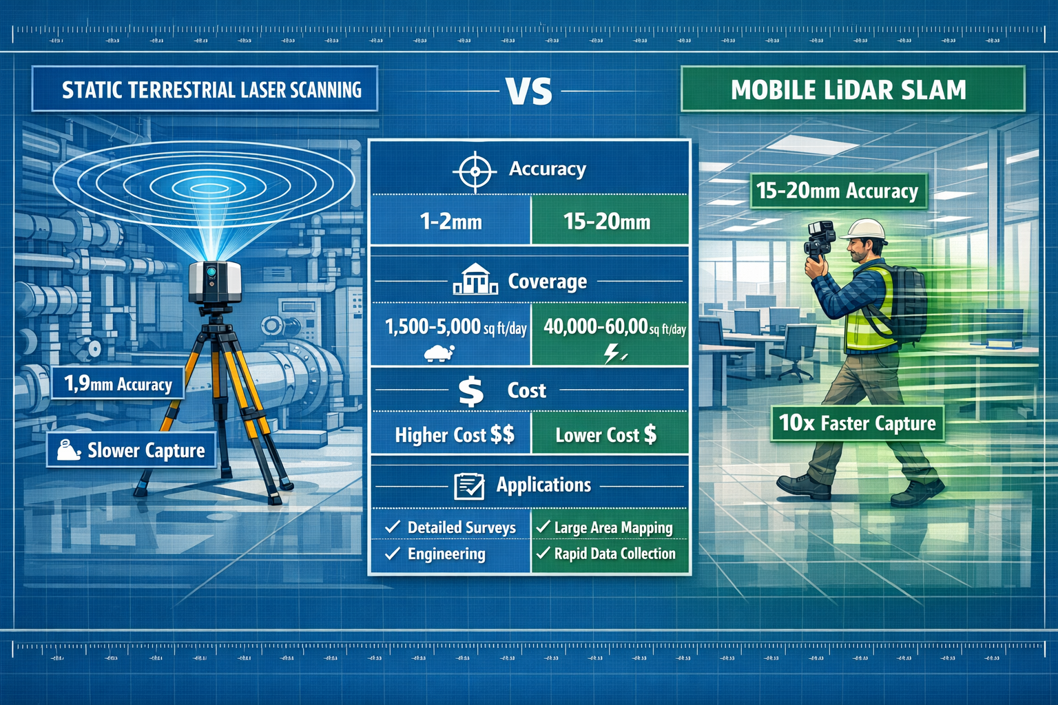
- Survey-grade precision: Achieves accuracy of 1.9mm, essential for applications where subtle variations matter[1]
- High point density: Captures millions of measurements per second, creating exceptionally detailed point clouds
- Optimal for critical areas: Mechanical rooms, structural assessments, floor flatness (FF/FL) measurements
- Controlled environment performance: Works best in stable conditions where the scanner can maintain position
The trade-off for this exceptional precision is time and labor intensity. Static scanners typically capture 10,000–15,000 square feet per day, requiring multiple setup positions throughout a building and careful registration between scan locations.[1] For a large commercial property, this methodical approach can extend fieldwork across several days or even weeks.
Mobile LiDAR (SLAM): Speed Meets Practicality
Mobile LiDAR systems using Simultaneous Localization and Mapping (SLAM) technology represent the evolution of laser scanning toward rapid, accessible reality capture. These handheld or backpack-mounted devices allow surveyors to walk through spaces while continuously scanning, capturing data at walking speed without requiring stationary setup positions.
Mobile LiDAR delivers:
- Real-world accuracy of 15–20mm: Within the ~1-inch tolerance required for BOMA 2026 Rentable Area calculations[1]
- 10x faster capture speed: 100,000–150,000 square feet per day compared to static systems[1]
- Operational flexibility: Navigate stairs, tight corridors, and complex layouts without repositioning equipment
- Reduced field time: Complete large-scale projects in days rather than weeks
Modern mobile scanning hardware like the Trimble X9, NavVis VLX 3, and Leica RTC360 achieves 2 million points per second, dramatically improving efficiency compared to legacy systems from just a decade ago.[3][1] This performance leap has made mobile scanning economically viable for projects where traditional static scanning would be prohibitively expensive.
Mobile vs. Traditional Methods: The Reality Capture Revolution
Traditional Property Assessment Challenges
Before the widespread adoption of 3D Laser Scanning and Mobile Mapping: Capturing Reality for Precise Property Assessments, property surveyors faced significant challenges:
📏 Manual measurement limitations: Tape measures and distance meters required physical access to every measured point, creating safety concerns and access difficulties in complex buildings
⏰ Time-intensive fieldwork: Comprehensive property assessment could take weeks for large commercial properties, delaying project timelines
❌ Human error risks: Manual data recording introduced transcription errors, missed measurements, and inconsistencies between team members
📊 Limited documentation: Traditional methods captured only selected measurements rather than complete spatial records, making future verification impossible
💰 Multiple site visits: Discovering missed measurements often required expensive return trips to properties
These limitations created particular challenges for urban properties where complexity, scale, and stakeholder expectations demanded more comprehensive documentation than traditional methods could efficiently deliver.
How Mobile Mapping Transforms the Assessment Process
Mobile mapping systems address these traditional challenges through several key innovations:
Continuous data capture eliminates the risk of missed measurements. As surveyors walk through a property, the mobile scanner captures everything in its field of view, creating a complete record that can be revisited virtually for any additional measurements needed during design or analysis phases.[4]
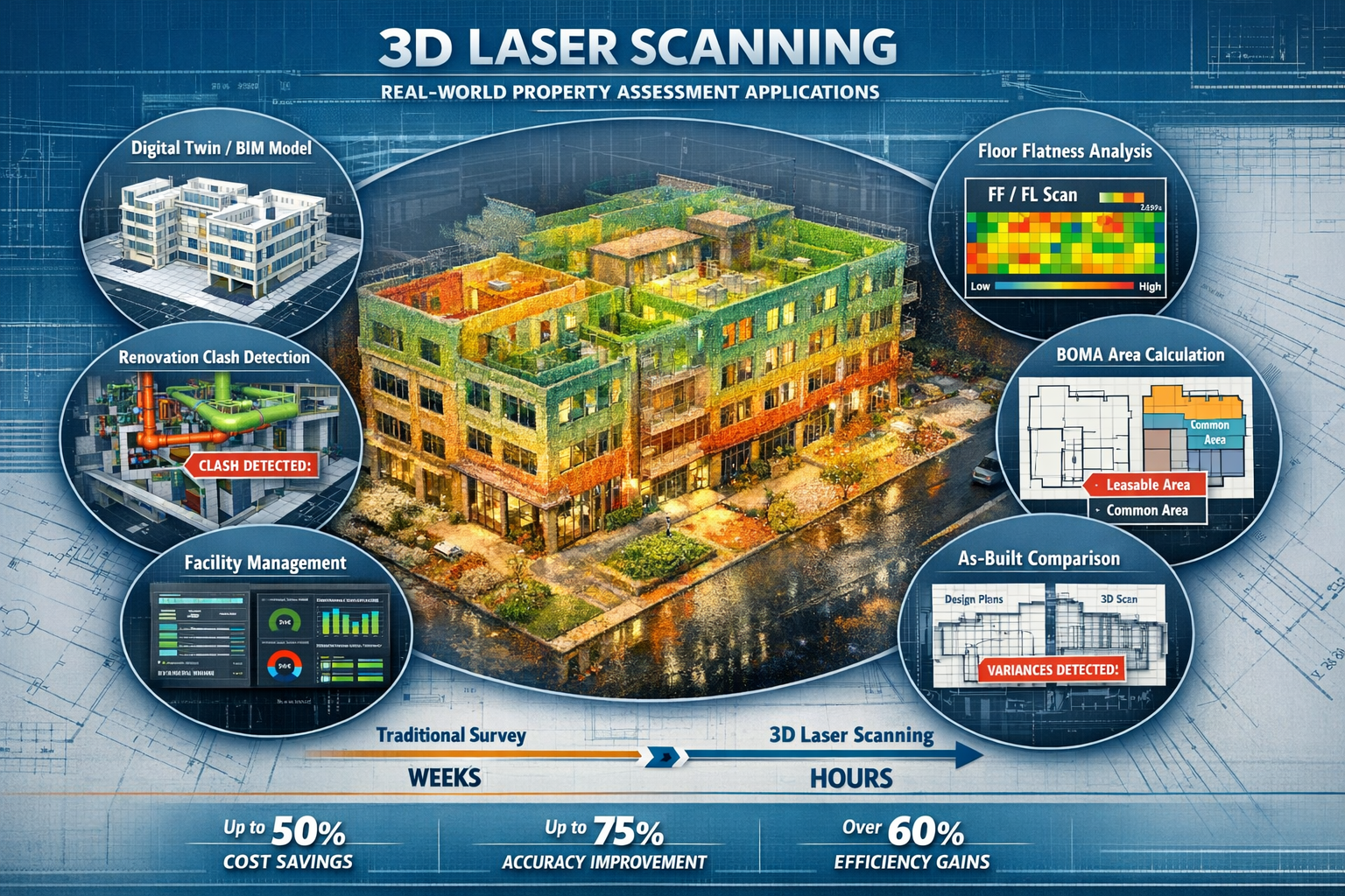
Rapid deployment means laser scanning accelerates data collection from weeks to hours, with in-field registration and auto-calibration reducing project timelines significantly.[3] A 500,000 square foot office tower that might require two weeks of traditional surveying can be comprehensively scanned in just 3-4 days using mobile systems.
Enhanced safety keeps surveyors out of hazardous areas. Rather than climbing scaffolding or accessing dangerous spaces with measuring equipment, surveyors can capture detailed measurements from safe positions, with the laser beams reaching areas that would be risky to access physically.
Complete spatial context preserves relationships between building elements that isolated measurements cannot capture. The resulting point clouds show how spaces connect, where conflicts exist, and how proposed changes will interact with existing conditions—critical information for building surveys and renovation projects.
Accuracy Comparison: Meeting Project Requirements
Understanding accuracy requirements is essential for selecting appropriate scanning technology:
| Application | Required Accuracy | Recommended Technology | Typical Use Cases |
|---|---|---|---|
| Mechanical Room Documentation | ±2mm | Static TLS | Pipe routing, equipment clearances, retrofit planning |
| Floor Flatness (FF/FL) | ±1.9mm | Static TLS | Warehouse assessments, flooring specifications |
| BOMA Rentable Area | ±25mm (~1 inch) | Mobile LiDAR | Office tower leasing, space planning |
| As-Built Surveys | ±15-20mm | Mobile LiDAR or Hybrid | General documentation, facility management |
| Facade Analysis | ±5mm | Static TLS | Cladding assessments, structural monitoring |
| Interior Space Planning | ±20mm | Mobile LiDAR | Office layouts, tenant improvements |
Both technologies achieve centimeter-level or better accuracy, sufficient for eliminating guesswork in design and renovation projects where digital twins must match existing layouts precisely.[2] The choice between them depends on project economics, timeline constraints, and the specific accuracy requirements of the deliverables.
Practical Applications of 3D Laser Scanning and Mobile Mapping in Property Assessments
Commercial Property Documentation and BOMA Calculations
One of the most valuable applications of 3D Laser Scanning and Mobile Mapping: Capturing Reality for Precise Property Assessments is documenting commercial properties for leasing and space management. The Building Owners and Managers Association (BOMA) standards require precise measurement of rentable areas, and mobile LiDAR delivers the 15–20mm accuracy that falls comfortably within the ~1-inch tolerance required for BOMA 2026 Rentable Area calculations.[1]
For property owners and managers, this capability translates directly to revenue optimization. Accurate BOMA measurements ensure that every rentable square foot is properly documented and billed, while tenants gain confidence that their lease calculations reflect actual space allocations. The comprehensive point cloud data also supports space planning, enabling landlords to quickly model different tenant configurations and maximize building utilization.
Mobile scanning is designated optimal for office towers and warehouses specifically because the speed advantage allows entire buildings to be captured in days rather than weeks, making the economics favorable even for routine documentation updates.[1]
As-Built Documentation for Renovation and Retrofit Projects
Renovation projects face a fundamental challenge: existing building documentation is often incomplete, outdated, or inaccurate. 3D laser scanning solves this problem by creating precise as-built records that serve as the foundation for design work.[5]
When architects and engineers begin retrofit projects, they need to understand exactly what exists—not what was originally designed. Walls shift during construction, mechanical systems deviate from plans, and decades of modifications create conditions that bear little resemblance to archived drawings. Point cloud data captures reality as it exists today, enabling design teams to identify conflicts before construction begins and eliminating costly field changes.
The workflow typically involves:
- Field capture: Mobile scanning teams walk through the property, capturing comprehensive point cloud data
- Registration and processing: Point clouds are aligned and cleaned to create a unified spatial model
- Scan-to-BIM modeling: Specialized technicians extract architectural features from point clouds to create Building Information Models (BIM)
- Design integration: Architects overlay proposed designs onto existing conditions to identify conflicts and optimize solutions
This approach is particularly valuable for property maintenance requirements planning, where facility managers need accurate records of building systems to schedule preventive maintenance and plan capital improvements.
Structural Assessment and Condition Monitoring
Static laser scanning excels at applications requiring extreme precision, particularly for structural assessments where subtle variations indicate potential problems. Floor flatness measurements, for example, require the 1.9mm accuracy that only static TLS can reliably deliver.[1]
For warehouse properties, floor flatness directly impacts operational efficiency. Automated guided vehicles (AGVs) and high-bay storage systems require floors that meet specific FF/FL (floor flatness/floor levelness) specifications. Laser scanning provides comprehensive floor surface mapping that identifies problem areas and quantifies deviations from specification—critical information for property valuation and operational planning.
Facade analysis represents another high-precision application where static scanning proves essential. Building cladding systems experience thermal expansion, settling, and material degradation over time. Periodic laser scanning creates detailed records of facade geometry, enabling engineers to track changes, identify displacement patterns, and plan maintenance interventions before failures occur.[2]
Facility Management and Digital Twin Creation
The concept of digital twins—virtual replicas of physical assets—has transformed facility management practices. 3D laser scanning provides the foundational data for creating digital twins that support ongoing building operations.[7]
Facility managers use digital twins for:
- Space management: Track occupancy, plan reconfigurations, optimize utilization
- Maintenance planning: Access precise measurements of building systems without site visits
- Emergency response: Provide first responders with detailed building layouts and access routes
- Capital planning: Model proposed improvements and estimate costs with accurate existing conditions data
- Compliance documentation: Maintain records for accessibility, safety, and regulatory requirements
Modern facility management platforms integrate point cloud data with operational systems, creating interactive environments where managers can visualize building performance, track assets, and plan interventions—all from a desktop interface that reflects actual building conditions with centimeter-level precision.
Boundary Disputes and Property Rights Documentation
While less common than other applications, laser scanning provides valuable evidence for resolving property disputes and documenting property rights. The technology creates objective, time-stamped records of property boundaries, encroachments, and spatial relationships that can support legal proceedings.
For properties with complex property boundary guidelines or disputed easements, point cloud data provides irrefutable evidence of existing conditions. Courts increasingly accept laser scan data as authoritative documentation, particularly when surveys are conducted by qualified professionals using calibrated equipment and following established protocols.
Implementing Hybrid Workflows: Best Practices for Property Assessment Projects
The Industry Consensus: Static + Mobile Integration
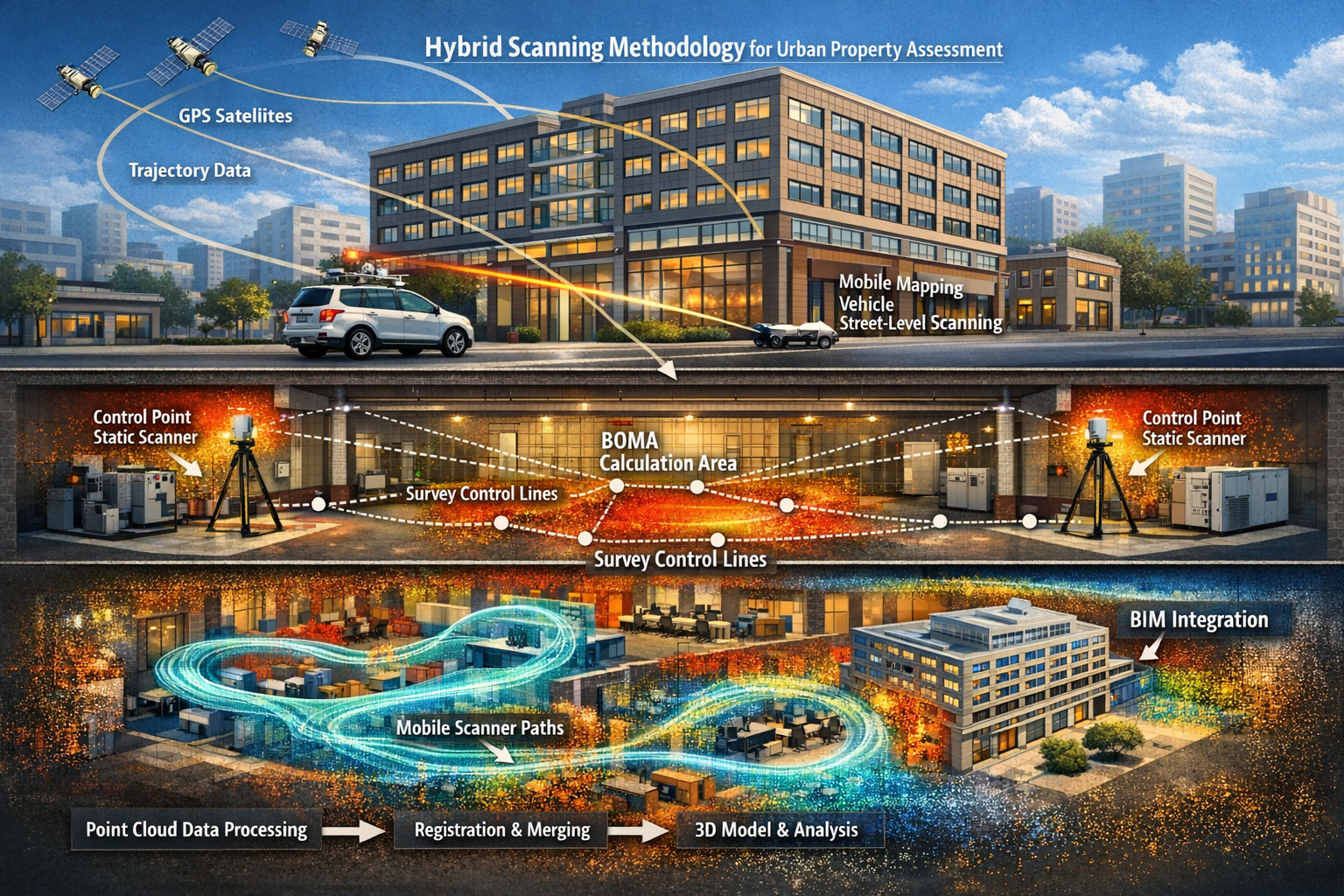
Professional surveying firms have converged on a hybrid workflow that combines the strengths of both technologies. This approach uses static scanners to capture the "skeleton"—survey control points and critical mechanical areas—while mobile scanners handle the "meat"—rapid infill and general documentation.[1]
The hybrid methodology typically follows this sequence:
Phase 1: Survey Control Establishment
- Deploy static laser scanners at strategic control points throughout the property
- Establish precise spatial reference framework with survey-grade accuracy
- Capture high-precision scans of mechanical rooms, critical infrastructure, and areas requiring detailed analysis
Phase 2: Rapid Space Capture
- Use mobile LiDAR to quickly capture remaining interior spaces
- Walk through corridors, offices, common areas, and large open spaces
- Leverage the 10x speed advantage to complete comprehensive coverage in minimal time
Phase 3: Data Integration
- Register mobile scan data to the static control framework
- Create unified point cloud dataset combining precision and coverage
- Perform quality control checks to ensure alignment meets project specifications
This hybrid approach delivers optimal project economics. The field capture costs are reduced by 50–70% compared to all-static workflows because mobile systems handle the bulk of the square footage.[1] While scan-to-BIM modeling costs increase by 15–20% when working with mobile data (because walls appear as "fuzzy" approximately 15mm-thick features rather than sharp lines), the overall project savings and timeline improvements typically justify this trade-off.[1]
Technology Selection Criteria
Choosing the right scanning technology for a specific project requires evaluating several factors:
Accuracy requirements: What level of precision do deliverables require? BOMA calculations accept ±25mm, while mechanical coordination may demand ±2mm.[1]
Project scale: How large is the property? Mobile systems become increasingly cost-effective as square footage increases beyond 50,000 square feet.
Timeline constraints: When are deliverables needed? Mobile scanning can compress field work from weeks to days, accelerating project schedules.
Budget considerations: What resources are available? While mobile field costs are lower, total project costs depend on deliverable requirements and post-processing needs.
Deliverable complexity: What outputs are required? Simple as-built drawings have different processing requirements than detailed BIM models or structural analysis datasets.
Access limitations: Are there areas that are difficult or dangerous to access? Mobile systems navigate complex spaces more easily than static scanners requiring stable positioning.
Cost Considerations and ROI
Understanding the economics of 3D Laser Scanning and Mobile Mapping: Capturing Reality for Precise Property Assessments helps stakeholders make informed decisions about technology adoption.
Hardware investment has become more accessible as costs have dropped significantly while performance has improved dramatically. Scanning modules now integrate into existing software packages rather than requiring entirely new system purchases.[3] Professional-grade mobile LiDAR systems range from £30,000 to £100,000 depending on capabilities, while static scanners typically cost £40,000 to £150,000.
Field labor costs represent the largest variable expense. Mobile systems reduce field time by 50–70% compared to static scanning, translating directly to labor savings.[1] For a 200,000 square foot commercial property, mobile scanning might require 2-3 days of field work versus 10-14 days for comprehensive static scanning.
Processing and modeling costs vary based on deliverable requirements. Point cloud registration and cleaning typically cost £500-£2,000 per project depending on complexity. Scan-to-BIM modeling ranges from £0.50 to £3.00 per square foot depending on detail level, with mobile LiDAR data commanding a 15–20% premium due to interpretation requirements.[1]
Return on investment for property owners comes from multiple sources:
💰 Reduced design errors: Accurate existing conditions data eliminates costly field changes during construction
⏱️ Accelerated project timelines: Faster data collection enables earlier design starts and shorter project durations
📊 Optimized space utilization: Precise BOMA calculations ensure maximum rentable area documentation
🔧 Improved maintenance planning: Digital twins support predictive maintenance and capital planning
⚖️ Risk mitigation: Comprehensive documentation reduces disputes and supports informed decision-making
For most commercial property projects, the technology investment pays for itself within the first few applications through avoided costs and improved outcomes.
Quality Control and Validation
Ensuring data quality requires systematic quality control processes throughout the scanning workflow:
Pre-scan planning identifies optimal scanner positions, establishes survey control requirements, and defines accuracy specifications. Professional surveyors conduct site reconnaissance to understand access constraints, identify critical areas requiring high precision, and plan efficient capture sequences.
Field verification includes real-time data quality checks using scanner software to identify coverage gaps, registration errors, and data quality issues while still on site. Modern scanners provide immediate feedback about point cloud density and registration accuracy, enabling surveyors to address problems before demobilizing.
Post-processing validation involves comparing point cloud data against known control measurements, checking registration accuracy across scan positions, and verifying that deliverable accuracy meets project specifications. Quality control reports document achieved accuracy and identify any limitations or constraints.
Deliverable review ensures that final products—whether CAD drawings, BIM models, or analytical reports—accurately represent the captured point cloud data and meet client requirements. Independent review by senior professionals provides an additional quality assurance layer for critical projects.
The Future of Property Assessments: Reality Capture Goes Mainstream
Technology Democratization and Accessibility
The most significant trend in 2026 is the democratization of reality capture technology. What was once specialized equipment requiring extensive training and significant capital investment has become accessible to a broader range of professionals.[4]
Smartphone-based scanning using LiDAR sensors built into consumer devices has emerged as a viable option for basic property documentation. While not matching the precision of professional systems, smartphone scanning provides sufficient accuracy for preliminary assessments, space planning, and general documentation at minimal cost.
Cloud-based processing platforms have eliminated the need for specialized workstations and software expertise. Surveyors can upload point cloud data to cloud services that automatically register scans, extract measurements, and generate deliverables—reducing the technical barriers that previously limited technology adoption.
Integrated workflows connect scanning hardware directly to design and analysis software, streamlining the path from field capture to final deliverables. Modern platforms support direct import of point cloud data into BIM environments, enabling real-time design validation against existing conditions.
This accessibility shift means that reality capture has moved from specialized applications to standard practice for property assessments in 2026. What was exceptional five years ago is now expected by clients who understand the value of comprehensive spatial documentation.[5]
Integration with Geographic Information Systems (GIS)
The convergence of laser scanning with Geographic Information Systems (GIS) creates powerful capabilities for urban property assessment and planning. Mobile mapping systems equipped with GPS receivers capture not just building interiors but also precise exterior geometry and site context.
Outdoor-indoor integration enables comprehensive property documentation that seamlessly transitions from street-level context to interior spaces. This capability is particularly valuable for urban properties where site constraints, access routes, and neighborhood context significantly impact property value and development potential.
City-scale mapping initiatives in major urban centers have created publicly available point cloud datasets that provide context for individual property assessments. These datasets support comparative analysis, neighborhood planning, and infrastructure coordination—extending the value of reality capture beyond individual properties to entire urban districts.
Artificial Intelligence and Automated Feature Extraction
Machine learning algorithms are transforming how professionals extract information from point cloud data. Rather than manually identifying and measuring building features, AI-powered software can automatically recognize walls, doors, windows, mechanical systems, and structural elements—dramatically reducing processing time and cost.
Automated BIM generation from point clouds is approaching practical viability for standard building types. While complex or historic structures still require manual interpretation, modern office buildings and warehouses can be automatically converted from point clouds to basic BIM models with minimal human intervention.
Defect detection algorithms identify anomalies, damage, and maintenance issues by comparing captured point clouds against design specifications or previous scan data. This capability supports predictive maintenance programs and enables early intervention before minor issues escalate into major problems.
Regulatory Adoption and Standards Development
Professional organizations and regulatory bodies have increasingly recognized laser scanning as a standard methodology for property documentation. RICS (Royal Institution of Chartered Surveyors) and other professional bodies have published guidance on reality capture best practices, establishing quality standards and professional competency requirements.
BOMA standards have evolved to explicitly accommodate laser scanning methodologies for rentable area calculations, providing clear protocols for scan-based measurements that ensure consistency and accuracy across properties.[1]
Building regulations in some jurisdictions now reference point cloud data as acceptable documentation for compliance verification, particularly for complex renovations where traditional as-built drawings may not accurately reflect existing conditions.
This regulatory recognition provides professional validation for technology adoption and creates clear frameworks for quality assurance and professional liability—essential foundations for mainstream practice.
Overcoming Common Challenges and Misconceptions
Addressing Data Management Concerns
One frequently cited concern about laser scanning is data volume. Point clouds can contain hundreds of millions of data points, creating files that measure gigabytes or even terabytes for large properties. This scale raises legitimate questions about storage, processing, and long-term data management.
Modern solutions address these concerns through:
- Cloud storage platforms designed specifically for point cloud data, with efficient compression and streaming capabilities
- Level-of-detail (LOD) processing that creates multiple resolution versions optimized for different uses
- Intelligent data reduction that preserves accuracy while eliminating redundant points
- Standardized file formats (E57, LAS, LAZ) that ensure long-term accessibility and cross-platform compatibility
For most property assessment projects, data management is a solved problem rather than a barrier to adoption. Professional surveying firms maintain established workflows for archiving, accessing, and sharing point cloud data with project stakeholders.
Understanding Processing Requirements and Timelines
Another common misconception is that laser scanning provides "instant" deliverables. While field capture is dramatically faster than traditional methods, post-processing requires time and expertise to convert raw point clouds into usable deliverables.
Realistic processing timelines include:
- Point cloud registration and cleaning: 1-3 days for typical commercial properties
- Basic CAD floor plans: 3-7 days depending on complexity and detail requirements
- Detailed BIM models: 2-4 weeks for comprehensive architectural models
- Specialized analysis (structural, mechanical, facade): Variable depending on scope
Setting appropriate expectations about processing timelines ensures that project schedules account for the complete workflow from field capture through final deliverables. While total project duration may still be shorter than traditional methods, the time savings come primarily from reduced field work rather than instantaneous results.
Selecting Qualified Service Providers
The accessibility of scanning technology has created a diverse market of service providers with varying levels of expertise and capability. Selecting qualified professionals is essential for achieving reliable results.
Key qualifications to evaluate include:
✓ Professional credentials: RICS membership, professional surveyor qualifications, industry certifications
✓ Equipment capabilities: Modern, calibrated scanning systems appropriate for project requirements
✓ Project experience: Demonstrated expertise with similar property types and deliverable requirements
✓ Quality assurance processes: Documented QC procedures and accuracy validation protocols
✓ Insurance coverage: Professional indemnity insurance appropriate for project scope
✓ Reference projects: Verifiable track record with comparable properties and stakeholders
When evaluating property survey expenses, the lowest bid may not represent the best value. Professional expertise, reliable deliverables, and appropriate quality assurance justify premium pricing for critical projects where accuracy and reliability are essential.
Conclusion: Embracing the Future of Property Assessment
3D Laser Scanning and Mobile Mapping: Capturing Reality for Precise Property Assessments represents more than just technological advancement—it fundamentally transforms how professionals understand, document, and value properties in 2026. The convergence of static precision and mobile efficiency creates workflows that deliver unprecedented accuracy while dramatically reducing project timelines and costs.
The evidence is compelling: mobile LiDAR operates 10 times faster than static scanning while achieving the 15–20mm accuracy required for most property assessment applications.[1] Static scanners provide the 1.9mm precision essential for critical measurements and survey control.[1] Together, these technologies enable hybrid workflows that optimize project economics while ensuring deliverables meet stakeholder requirements.
For property owners, investors, and facility managers, reality capture technology offers tangible benefits that extend far beyond novelty or technical sophistication. Accurate BOMA calculations maximize revenue. Comprehensive as-built documentation reduces renovation costs. Digital twins support efficient facility management. Precise condition assessment informs maintenance planning and capital allocation.
For surveyors and assessment professionals, mastering these technologies is no longer optional—it's essential for remaining competitive in a market where clients increasingly expect comprehensive spatial documentation as standard practice rather than premium service.[5]
Actionable Next Steps
For property owners and managers:
- Evaluate current documentation: Assess whether existing building records accurately reflect current conditions
- Identify high-value applications: Prioritize projects where accurate spatial data delivers clear ROI (renovations, BOMA calculations, facility management)
- Engage qualified professionals: Select scanning service providers with appropriate credentials, experience, and quality assurance processes
- Plan for digital twin integration: Consider how point cloud data can support ongoing facility management and strategic planning
- Budget appropriately: Understand total project costs including both field capture and deliverable processing
For assessment professionals:
- Invest in technology and training: Develop in-house capabilities or establish partnerships with specialized scanning firms
- Understand client requirements: Learn to match scanning technology (static, mobile, or hybrid) to specific project needs and budgets
- Develop processing workflows: Establish efficient procedures for converting point clouds into client deliverables
- Maintain quality standards: Implement robust QC processes that ensure deliverables meet accuracy specifications
- Communicate value effectively: Help clients understand how reality capture delivers tangible benefits beyond traditional assessment methods
For project stakeholders:
- Specify accuracy requirements clearly: Define deliverable precision based on actual project needs rather than assuming maximum accuracy is always necessary
- Plan realistic timelines: Account for both field capture and post-processing when establishing project schedules
- Leverage existing data: When available, use point cloud data from previous projects to reduce current project scope and cost
- Support data sharing: Establish protocols for sharing point cloud data across project teams to maximize value and minimize redundant capture
- Stay informed about capabilities: Technology continues evolving rapidly—maintain awareness of emerging capabilities and applications
The transformation of property assessment through 3D laser scanning and mobile mapping is not a future possibility—it's current reality in 2026. Organizations that embrace these technologies gain competitive advantages through improved accuracy, reduced costs, and enhanced capabilities. Those that delay adoption risk falling behind in a market where comprehensive spatial documentation has become the expected standard.
The question is no longer whether to adopt reality capture technology, but how to implement it most effectively to serve client needs, optimize project economics, and deliver the precise property assessments that modern stakeholders demand. For those ready to take the next step, the technology, expertise, and proven workflows are readily available—transforming property assessment from an art of estimation to a science of precision.
References
[1] 3d Laser Scanning Vs Lidar Differences – https://iscano.com/laser-scanning-lidar-technology/3d-laser-scanning-vs-lidar-differences/
[2] Benefits Of 3d Laser Scanning – https://eagle-eac.com/benefits-of-3d-laser-scanning/
[3] 3d Laser Scanning New Opportunities For Surveying And Mapping Professionals – https://geospatial.trimble.com/blog/geospatial/en-US/article/3d-laser-scanning-new-opportunities-for-surveying-and-mapping-professionals
[4] Reality Capture Goes Mainstream Accessible Tools Transforming Property Surveys In 2026 – https://nottinghillsurveyors.com/blog/reality-capture-goes-mainstream-accessible-tools-transforming-property-surveys-in-2026
[5] 3d Laser Scanning For Property Surveys From Adoption Boom To Practical Implementation – https://nottinghillsurveyors.com/blog/3d-laser-scanning-for-property-surveys-from-adoption-boom-to-practical-implementation
[6] 7 Reasons To Use Lidar Construction Laser Scanning – https://blog.brightergraphics.com/7-reasons-to-use-lidar-construction-laser-scanning
[7] 3d Laser Scanning And The New Era Of Facility Management – https://www.faro.com/en/Resource-Library/Article/3D-Laser-Scanning-and-the-New-Era-of-Facility-Management
[8] San Diego – https://www.gp-radar.com/laser-scanning-city/san-diego